924
Lectures Watched
Since January 1, 2014
Since January 1, 2014
- A History of the World since 1300 (68)
- History of Rock, 1970-Present (50)
- A Brief History of Humankind (48)
- Chinese Thought: Ancient Wisdom Meets Modern Science (35)
- The Modern World: Global History since 1760 (35)
- The Bible's Prehistory, Purpose, and Political Future (28)
- Introduction aux éthiques philosophiques (27)
- Jesus in Scripture and Tradition (25)
- Roman Architecture (25)
- Sexing the Canvas: Art and Gender (23)
- Descubriendo la pintura europea de 1400 a 1800 (22)
- Introduction aux droits de l'homme (19)
- Buddhism and Modern Psychology (18)
- Calvin: Histoire et réception d'une Réforme (17)
- The Ancient Greeks (16)
- À la découverte du théâtre classique français (15)
- The French Revolution (15)
- Letters of the Apostle Paul (14)
- Key Constitutional Concepts and Supreme Court Cases (14)
- Christianisme et philosophie dans l'Antiquité (14)
- Egiptología (12)
- Western Music History through Performance (10)
- The Rise of Superheroes and Their Impact On Pop Culture (9)
- The Great War and Modern Philosophy (9)
- Alexander the Great (9)
- Greek and Roman Mythology (9)
- Human Evolution: Past and Future (9)
- Phenomenology and the Conscious Mind (9)
- Masterpieces of World Literature (8)
- Villes africaines: la planification urbaine (8)
- Greeks at War: Homer at Troy (7)
- Pensamiento Científico (7)
- MongoDB for Node.js Developers (7)
- Fundamentos de la escritura en español (7)
- Introduction to Psychology (7)
- Programming Mobile Applications for Android (7)
- The Rooseveltian Century (6)
- Karl der Große - Pater Europae (6)
- Fake News, Facts, and Alternative Facts (6)
- Reason and Persuasion Through Plato's Dialogues (6)
- The Emergence of the Modern Middle East (6)
- A Beginner's Guide to Irrational Behavior (6)
- Lingua e cultura italiana: avanzata (6)
- L'avenir de la décision : connaître et agir en complexité (5)
- Understanding Einstein: The Special Theory of Relativity (5)
- Dinosaur Paleobiology (5)
- Exploring Beethoven's Piano Sonatas (5)
- War for the Greater Middle East (4)
- Emergence of Life (4)
- Introduction to Public Speaking (4)
- The Kennedy Half Century (4)
- Problèmes métaphysiques à l'épreuve de la politique, 1943-1968 (4)
- Designing Cities (4)
- Western Civilization: Ancient and Medieval Europe (3)
- Paleontology: Early Vertebrate Evolution (3)
- Orientierung Geschichte (3)
- Moons of Our Solar System (3)
- Introduction à la philosophie de Friedrich Nietzsche (3)
- Devenir entrepreneur du changement (3)
- La Commedia di Dante (3)
- History of Rock and Roll, Part One (3)
- Formation of the Universe, Solar System, Earth and Life (3)
- Initiation à la programmation en Java (3)
- La visione del mondo della Relatività e della Meccanica Quantistica (3)
- The Music of the Beatles (3)
- Analyzing the Universe (3)
- Découvrir l'anthropologie (3)
- Postwar Abstract Painting (3)
- The Science of Religion (2)
- La Philanthropie : Comprendre et Agir (2)
- Highlights of Modern Astronomy (2)
- Materials Science: 10 Things Every Engineer Should Know (2)
- The Changing Landscape of Ancient Rome (2)
- Lingua e letteratura in italiano (2)
- Gestion des aires protégées en Afrique (2)
- Géopolitique de l'Europe (2)
- Introduction à la programmation en C++ (2)
- Découvrir la science politique (2)
- Our Earth: Its Climate, History, and Processes (2)
- The European Discovery of China (2)
- Understanding Russians: Contexts of Intercultural Communication (2)
- Philosophy and the Sciences (2)
- Søren Kierkegaard: Subjectivity, Irony and the Crisis of Modernity (2)
- The Fall and Rise of Jerusalem (2)
- The Science of Gastronomy (2)
- Galaxies and Cosmology (2)
- Introduction to Classical Music (2)
- Art History for Artists, Animators and Gamers (2)
- L'art des structures 1 : Câbles et arcs (2)
- Russian History: from Lenin to Putin (2)
- The World of Wine (1)
- Wine Tasting: Sensory Techniques for Wine Analysis (1)
- William Wordsworth: Poetry, People and Place (1)
- The Talmud: A Methodological Introduction (1)
- Switzerland in Europe (1)
- The World of the String Quartet (1)
- Igor Stravinsky’s The Rite of Spring (1)
- El Mediterráneo del Renacimiento a la Ilustración (1)
- Science of Exercise (1)
- Социокультурные аспекты социальной робототехники (1)
- Russian History: from Lenin to Putin (1)
- The Rise of China (1)
- The Renaissance and Baroque City (1)
- Visualizing Postwar Tokyo (1)
- In the Night Sky: Orion (1)
- Oriental Beliefs: Between Reason and Traditions (1)
- The Biology of Music (1)
- Mountains 101 (1)
- Moral Foundations of Politics (1)
- Mobilité et urbanisme (1)
- Introduction to Mathematical Thinking (1)
- Making Sense of News (1)
- Magic in the Middle Ages (1)
- Introduction to Italian Opera (1)
- Intellectual Humility (1)
- The Computing Technology Inside Your Smartphone (1)
- Human Origins (1)
- Miracles of Human Language (1)
- From Goddard to Apollo: The History of Rockets (1)
- Hans Christian Andersen’s Fairy Tales (1)
- Handel’s Messiah and Baroque Oratorio (1)
- Theater and Globalization (1)
- Gestion et Politique de l'eau (1)
- Une introduction à la géographicité (1)
- Frontières en tous genres (1)
- Créer et développer une startup technologique (1)
- Découvrir le marketing (1)
- Escribir para Convencer (1)
- Anthropology of Current World Issues (1)
- Poetry in America: Whitman (1)
- Introducción a la genética y la evolución (1)
- Shakespeare: On the Page and in Performance (1)
- The Civil War and Reconstruction (1)
- Dinosaur Ecosystems (1)
- Développement durable (1)
- Vital Signs: Understanding What the Body Is Telling Us (1)
- Imagining Other Earths (1)
- Learning How to Learn (1)
- Miracles of Human Language: An Introduction to Linguistics (1)
- Web Intelligence and Big Data (1)
- Andy Warhol (1)
- Understanding the Brain: The Neurobiology of Everyday Life (1)
- Practicing Tolerance in a Religious Society (1)
- Subsistence Marketplaces (1)
- Physique générale - mécanique (1)
- Exercise Physiology: Understanding the Athlete Within (1)
- Introduction to Mathematical Philosophy (1)
- What Managers Can Learn from Great Philosophers (1)
- A la recherche du Grand Paris (1)
- The New Nordic Diet (1)
- A New History for a New China, 1700-2000 (1)
- The Magna Carta and its Legacy (1)
- The Age of Jefferson (1)
- History and Future of Higher Education (1)
- Éléments de Géomatique (1)
- 21st Century American Foreign Policy (1)
- The Law of the European Union (1)
- Design: Creation of Artifacts in Society (1)
- Introduction to Data Science (1)
- Configuring the World (1)
- From the Big Bang to Dark Energy (1)
- Animal Behaviour (1)
- Programming Mobile Services for Android Handheld Systems (1)
- The American South: Its Stories, Music, and Art (1)
- Care of Elders with Alzheimer's Disease (1)
- Contagious: How Things Catch On (1)
- Constitutional Law - The Structure of Government (1)
- Narratives of Nonviolence in the American Civil Rights Movement (1)
- Christianity: From Persecuted Faith to Global Religion (200-1650) (1)
- Age of Cathedrals (1)
- Controversies of British Imperialism (1)
- Big History: From the Big Bang until Today (1)
- Bemerkenswerte Menschen (1)
- The Art of Poetry (1)
- Superpowers of the Ancient World: the Near East (1)
- America Through Foreign Eyes (1)
- Advertising and Society (1)
Hundreds of free, self-paced university courses available:
my recommendations here
my recommendations here
Peruse my collection of 275
influential people of the past.
influential people of the past.
View My Class Notes via:
Receive My Class Notes via E-Mail:
Contact Me via E-Mail:
edward [at] tanguay.info
Notes on video lecture:
Megacities and Megaregions
Notes taken by Edward Tanguay on January 8, 2016 (go to class or lectures)

Choose from these words to fill the blanks below:
emptied, driving, suburban, corrective, chauffeurs, cars, typical, congestion, Fractured, Front, Perimeter, entertainment, metro, Phoenix, affluent, gas, residential, southwest, school, 70%, urbanized, sea, Benelux, Dallas, Missouri, continuous, edge, Tyson, College, Gottmann, transit, commutes, walkable, Westport, ubiquitous
•
Kansas City is a U.S. city and can stand for what has happened and is happening in other places
•
river boats on the River
•
wagons carrying settlers Westward leaving from along the Santa Fe trail
•
railroad
•
connected to west coast
•
local street railways were built which enabled urban extensions
•
mostly south of the city center
•
new districts had landscaped streets and parks
•
the Country Club district
•
some could be reached by public
•
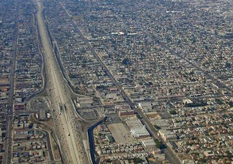
most of the extended development on the map could only be reached by car
•
by 1950, three of four households owned
•
at that time, the most automobile dependent country in the world
•
growth that followed street car tended to be along the line
•
growth in the suburbs began around railway stations
•
after the auto became more , roads were built anywhere
•
spread over the Kansas state line to
•
intended for middle and upper-income people
•
partly fueled by desegregating the Kansas City system
•
there was no busing over the state line
•
what happened in Kansas City was comparable to what happened in other U.S. cities
•
they were splitting into two parts: old city from 1950 and new city
•
"The Metropolis"
•
in most other countries, the old centers remained dominant
•
1. the old city: pre-1950 city
•
the original downtown was now at the periphery of the more new city
•
many of the old neighborhoods had out
•
at the time, it looked like everybody in the old cities were in deep trouble
•
everyone who had a choice were migrating to the new, affluent suburbs
•
had most of the new office buildings, best shopping, restaurants, and
•
2. the new city: suburban growth
•
developed retail and office centers of its own
•
more spread out than the old central city
•
e.g. Boulevard in Overland Park, Kansas
•
until 1970s was a far out suburb of Kansas City
•
some former intersections in suburbs with only one station can now have millions of square feet of office space and retail
•
cities
•
's Corner, Virginia has 46 million square feet of office space and retail
•
by comparison, downtown has 33 million square feet of office space and retail
•
Tyson's Corner is a prototype of an edge city
•
The Center, Atlanta
•
in far north corner of Atlanta
•
Galleria District, Uptown Houston
•
used to be residential suburbs
•
Westwood District, Los Angeles
•
Bloomington, Minnesota
•
upscale residential area has become office center
•
The Mall of America
•
largest shopping center in the United States
•
Clayton, Missouri
•
once an affluent suburb of St. Louis
•
connected back to St. Louis by link
•
1990s the new urban city kept on spreading to the point that it became dysfunctional for its residents
•
traffic
•
long to work
•
turned mothers with children into
•
shopping trips which required from one destination to another
•
the old 1950s city
•
with compact business center
•
old, walkable neighborhoods, started to look good in comparison
•
rise in real estate values for neighborhoods and suburbs
•
meanwhile the new suburban cities kept spreading out and became more and more dysfunctional and unsustainable
•
South Side Chicago
•
Scottsdale, Arizona
•
part of new city related to
•
San Jose, California
•
freeways and endless suburban development
•
to dependence on automobiles and sprawling development they create
•
transit system to connect centers of new city to traditional business center
•
e.g. between Tyson Center to Washington Metro system
•
Megalopolis = Big City
•
1961 Jean
•
cities that were close together and connected by rail and highways
•
in subsequent decades, these megacities became metaregions
•
Northeast
•
Great Lakes
•
Florida
•
Piedmont Atlantic
•
Gulf Coast
•
Texas Triangle
•
Arizona Sun Corridor
•
Range
•
Northern California
•
Southern California
•
by 2050 it is projected that of the population will be living in these regions
•
Europe
•
night views with lights reveal analogous pattern of city regions
•
countries
•
Northern Italy
•
China
•
Beijing: 20 million
•
Tianjing: 12 million
•
cities are growing together
•
Japan
•
much of Japan can be seen as a city
•
pulled together by well-established high-speed transport
•
South Korea
•
similarly
•
world
•
night satellite view shows energy use
•
sprawling cities are dominate living areas
•
by 2050, 3 billion more people
•
most of this grown in the city regions
•
many cities at coastlines
•
in danger if levels rise